Residential Land Uses (1100 Series)
Table of Contents
- Single-Family Residential, Detached (1111)
- Single-Family Residential, Attached (1112)
- Multi-Family Residential (1130)
- Mobile Home Parks and Trailer Courts (1140)
- Residential Common Open Space (1151)
Land in predominantly residential use, including surrounding land that is a part of a residential development. This category excludes housing on military bases as well as group quarters housing. Group quarters housing is included within their associated land use as defined below. Examples: military barracks are included as part of the military base which is defined as Governmental Administration and Services; nursing homes are included in Medical and Health Care Facilities; college dormitories would appear in Educational Facilities.
The difference between single-family and multi-family:
-
Single-Family Residential includes all single-family housing, as well as multi-unit structures (i.e. townhomes and duplexes) whose units do not share a common entryway, but rather, each unit has a separate front entrance. Residential parcels in established neighborhoods with no structures are included, with the RESUNIT count set to zero.
-
Multi-Family Residential includes multiple-unit residential buildings with a common entryway. Includes retirement complexes (except nursing homes), as well as two-flats, three-flats, condominiums and cooperatives. Also includes SROs (buildings with single-room occupancy). With two-flats and three-flats, while each unit may have a separate front entrance, the fact that one unit is on top of another unit puts it in the multi-family classification.
NOTE: If one parcel should happen to have BOTH single-family AND multi-family residential units in the SAME parcel, then go with the concept of coding to the more ACTIVE land use which in this case would be multi-family Residential.
AS OF THE 2015 INVENTORY we are attempting to assign residential unit estimates to every residential parcel, meaning:
- 1111 - Single-Family, Detached
- 1112 - Single-Family, Attached
- 1130 - Multi-Family
- 1140 - Mobile Home Park
- 1216 - Urban Mix with a Residential Component
As nice as it would be to have residential unit counts for the other categories, it isn’t practical to collect this information at the parcel level. Some parcels will already have residential units generated by pre-processing activities–leave those numbers in, but do not try to collect any additional information.
In the final version, the residential unit counts for Single-Family Detached and Attached will be used to generate estimates of residential density (housing units per acre). Density will also be inferred for other residential areas by the 1130 Multi-Family and 1140 Mobile Home Park codes.
Scattered Single-family or small-multi-family residences owned by an institution: Be aware that some individual houses or occasionally townhomes or small multi-family buildings may be owned by a government entity or a social service organization. When evidence supports that they are being used as residences, not offices, these should be coded with the appropriate residential code. Examples include homes owned by City of Elgin that house police officers and their families as part of the Resident Officer Program; individual houses scattered throughout Aurora owned by Aurora Housing Authority as low-income rental property; small group homes for disabled individuals owned by Association for Individual Development.
Single-Family Residential, Detached (1111)
Definition: One housing unit per free-standing residential structure. Can include un-developed Residential properties when adjacent to a developed property with the same owner. Residential unit estimate required.
Discussion: This is your classic “one home per parcel,” and is probably the most frequently-occurring use in the region. For most counties, a large number of properties were pre-coded using an automated (or query-based) approach; this was possible where we had access to a residential unit estimate (based on assessor coding) and an assessed value. The query operates on parcels where:
LU_PASS1 = 'RES'RES_UNITS = 1PARCELMOD = ''- County assessed value over a certain threshold (varies per county)
SHAPE_Area >= 8712(0.2 acres).
In McHenry County, this procedure accounted for nearly 50% of all of the parcels. In reality, there is likely some mis-coding of duplex buildings that sit on a single parcel. This is one of the hazards of automation, and will hopefully be caught by the diligent coder while working on the remaining residential parcels.
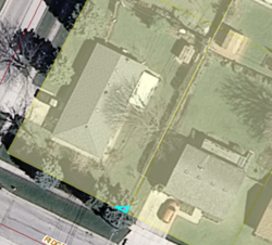
Very tiny parcels: Occasionally in residential areas, especially those with single-family detached parcels, you will find a very tiny parcel which has an owner that is completely different from any adjacent parcel. Possibly the county overlooked this tiny parcel for a name change when a house was sold to another party. Unless you have definitive evidence that something else is happening on this parcel, go ahead and code it the same as the other adjacent parcels which in Single-Family Detached neighborhoods would be 1111. Be sure this tiny parcel has a zero in the residential units field. Below is an example of such a tiny parcel.
Examples:
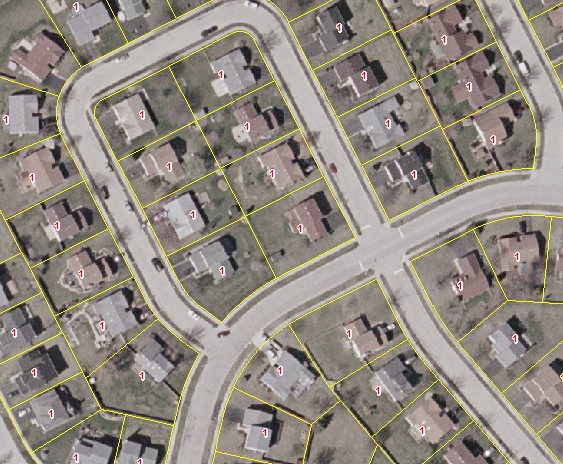
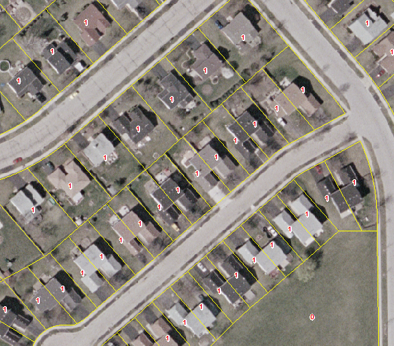
Suburban development, lots approximately 1/4-acre.
Q&A:
- Q: How do I handle it when a residential property with one owner is split over multiple parcels?
- A: All of the parcels should receive the 1111 (Res SF Detached) code if they are obviously part of a single property meaning the parcels are adjacent to one another; however, only one of the parcels should have a “1” value in the Residential Estimate field. All other parcels should have the Res Estimate field calculated to zero, if it doesn’t already hold that value. The “1” should be assigned to the parcel that has the higher Improvement Value. If the same homeowner also owns a parcel that is nearby, but not adjacent to that owner’s other parcels such as across the street or down the block, then this would be coded Residential Vacant 4110. One exception to this is if there is virtually nothing, no road or alley, between this parcel and the others that are part of the owner’s residential property, and it is obvious that the parcel in question is being used as part of the residential property. In this case you can also code it as part of the residential property with zero residential units.
- Q: What about a single undeveloped parcel within an established (neighborhood/subdivision)?
- A: If the parcel is of roughly equal size to the surrounding parcels and is not owned by someone who owns an adjacent, developed property, then that parcel gets coded 4110 Vacant Residential Land. However, if it is a newer subdivision that is simply not yet built out, then…
- …if it is farmed in the 2010 aerials, it should be coded Agriculture (2000), with PLATTED = “R”
- …if it is simply vacant (trees or grass), code it Vacant (4100), with PLATTED = “R”
- …if there is scraped earth or other evidence of constructions, code it 4210 Under Construction, Residential.
- A: One exception to the above 4110 code is if that undeveloped parcel which has a different owner from all the surrounding parcels, is land locked, meaning there’s no way to get to this property unless you cross property owned by someone else. In this case, code it with the same residential code as the surrounding parcels and make sure there’s “0” value in the residential units field. Vacant implies it can be built upon which is not likely in this case.
- A: If the parcel is of roughly equal size to the surrounding parcels and is not owned by someone who owns an adjacent, developed property, then that parcel gets coded 4110 Vacant Residential Land. However, if it is a newer subdivision that is simply not yet built out, then…
- Q: How do I code a separate parcel owned by a religous organization that primarily has a house on it while the actual religous organization building for assembly is on a different parcel?
- A: Code this as residential if only the house is on the parcel, not the building in which the congregation meets. Remember to code the residential units as “1”.
- Q: What if a house is used by a religious or other non-profit organization solely as offices and there is no indication that anyone lives in the house?
- A: Code the parcel for this house used solely as offices as 1215 urban mix.
- Q: Six houses are all on one parcel owned by a mission organization. How do I code this?
- A: Code this as 111 Single-family detached. Change the number in the residential units field to the number of houses on this one parcel which in this example would be “6”.
- Q: How do I code a parcel with a house on it and owner is a county health department?
- A: Unless you have information that this house is solely used as offices for the organization, assume that it is a residence. It is probably a group home run by a county organization. Code it 111 Single-family detached residential with residential units of “1”.
- Q: How do I code a parcel identified as AG by the county that has a farm house on it?
- A: If the parcel identified by the county as agriculture that has a house on it is 1 acre or less (43,560 sq ft) then code it 1111 Single-family detached with “1” in the residential units field. If the parcel is larger than that and agriculture is the appropriate code, then code it 2000 Agriculture. In this case, put nothing in the residential units field.
- Q: How do I code a relatively small parcel identified by the county as AG which is next to a residential parcel with the same owner. There’s a single family detached house on the residential parcel. The AG parcel has nothing on it that in any way would suggest agriculture; nothing that looks like it’s used for commercial agricultural.
-
A: Code this as 1111 Single family detached with “0” in the residential units field. Below is more about Rural Residential which is also discussed under Agriculture.
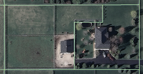
A house in a rural setting on a large parcel with a private barn and horses would be coded Residential unless there is evidence that it is a commercial equestrian operation. Below are two examples of Rural Residential which would be coded Residential Land Use even though the county may classify such land as agriculture or farm. In the first photo, this Rural Residence is on 3 parcels. The small one on the far right is the house. The other two are coded by the county as farm, but there is no evidence of any commercial crop or grazing so this is coded 1111 (Single-Family Detached) with one residential unit in the parcel containing the house and zero in the other two parcels, all of which have the same owner.
In the second photo, the house is in one parcel and the private horse stables are in an adjoining parcel with the same owner. This also will be coded as Residential.
-
- Q: How do I code parcels that are part of a homeowners association that has a private air strip?
- A: Code the parcels that strictly are part of the actual air strip and associated air transport facilities as 1530 Aircraft Transportation. Parcels for the housing will have the appropriate residential code as will also be true for any common open space which is part of the association.
- Q: In residential areas I occasionally have found what first appears to be a house owned by a government entity, usually a municipality. Upon closer inspection, I find it is a water pumping station in a house-like structure I guess to blend better into the neighborhood. How do I code this?
- A: Yes, you occasionally will find water pumping stations in neighborhoods masquerading as small houses! Code this 1564 Other Utility/Waste. In other cases, you may find a residence, usually a house, with a county government, non-profit social service agency, or religious organization owner. These are often group homes for agency clients or living quarters for members of that religious organization. Code these as you would any other residence based on the building structure.
- Q: How do I code a parcel that is identified as residential by the county and with 1 residential unit on it, but the aerial photo shows that the parcel has a small church and parking lot on it and also a house on it?
- A: Code this for the church and not for the house. Code it 1350 Religious and have 0 in the residential units field. Even though there is a house on this parcel, ONLY parcels coded as residential will contain a residential unit number in the final processing.
- Q: How do I code a model home owned by a developer which has not been sold yet to a private individual?
- A: Code a model home as whatever code is appropriate for that house structure, single-family detached or attached (1111 or 1112); put the appropriate number in the residential units field as though it had occupants. If an adjacent parcel is being used for parking for the model home or is just vacant and also owned by the developer, code this Residential Vacant 4110 because the parking will eventually be gone and a residence will most likely be built on the adjacent parcel. Because of the 2010 Landuse being used for modeling purposes, we must not just look at the specific way a particular parcel is being used in spring 2010 but also consider the overall purpose of the property.
- Q: How would one code a house that also has buildings and fencing determined by internet searches to be for dog breeding?
- A: Dog breeding does not fit our Landuse definition for Agriculture, so even if the county coded it as agriculture, code it as ’ 1100 Single-family Detached’ with 1 residential unit. If there is a Dun & Bradstreet point indicating a business AND you could see substantial buildings in addition to a house indicating significant business activity AND the county coded it commercial, you could consider coding it 1216 Urban Mix With Residential Component with no residential units needed.
- Q: How do I code a parcel owned by the State of Illinois that has 2 houses on it which appear to be occupied and used as homes, not offices for state employees. The county use code is Exempt. Zero is in the Residential Units field.
- A: The count in the Residential Units field is a guess based on other information found in the parcel data during pre-processing. In this case, the reason for the zero is because of the Exempt status by the county. The State of Illinois owns some parcels that continue to have active residences because they bought that land in anticipation of a future development project such as an expressway, a bypass, a new airport, etc. If you see evidence that the parcel is being used as residence, then even though it is owned by State of Illinois, code it with the appropriate Residential code and change the Residential Units to the correct number.
Single-Family Residential, Attached (1112)
Definition: Townhomes, duplexes, and other multi-unit structures whose units do not share a common entryway. Residential unit estimate required.
Discussion: Most (if not all) of the counties do not distinguish between detached and attached single-family residences. The planning community recognizes the distinction because of the “density” implications of attached dwellings. Because we are identifying attached dwellings apart from detached, a keen eye needs to be kept on the parcel outlines over the aerial photography to identify areas where parcel lines slice through buildings.
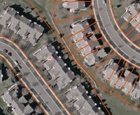
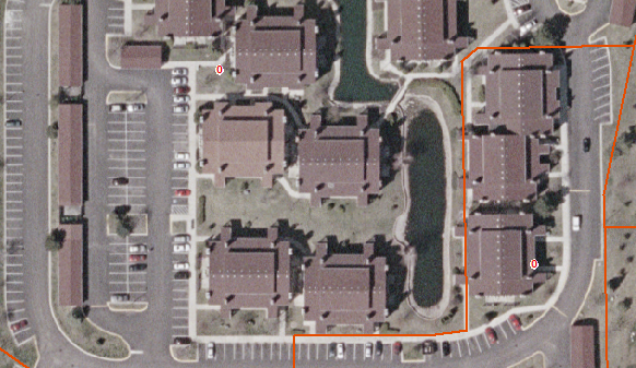
Examples: Below is an example of two townhome developments that would code to 1112. The property to the right is easy to spot since the parcel boundaries literally slice up the building by owner. The property to the left is part of the same development, but the county’s parcel file depicted it differently, forcing all of the units to get merged together into a single polygon during the pre-processing steps.
Duplexes. Note that the buildings are of similar size to the single-family detached to the north-west. Duplexes tend to have a more symmetrical footprint and, hopefully, have a parcel line running down through them.
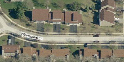
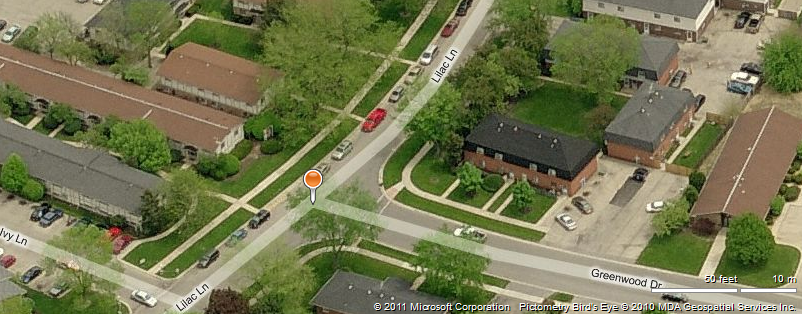
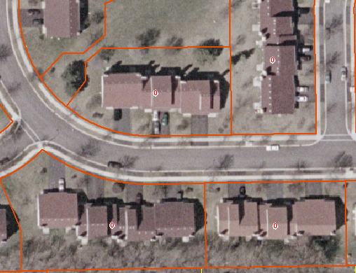
This is a rental property (entire parcel owned by a management agency), and could almost pass for multi-family, but it’s actually single-family attached, based on the definition. Note the numerous driveways in front of the building, suggesting that there is a separate garage (& entryway) for each unit. Below is the same development, shown in Bing Maps oblique (bird’s eye) imagery:
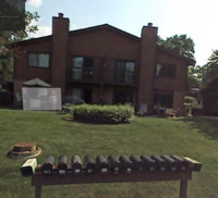
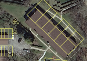
Below is an example of a 12-unit building in which each unit is a separate parcel. There are 6 units on each side of the building. These units as individually partitioned provides enough evidence to treat this as 1112 Single-Family Attached. A GoogleMaps Street View provides more evidence that each of the 12 units is a 2-story townhouse. Also, each townhouse unit has a separate parcel with the same owner name for garage parking for that townhouse unit. Be sure to have zero for the residential units for the separate garage parcels if they are, indeed, separate parcels. Also be aware, that sometimes each townhouse parcel and garage parcel is combined into one multi-part polygon.
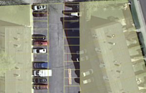
Below is another example of small parcels for parking that are separately-owned by the owners of the single-family attached units to the east and west of the parking. In this case, the spaces are not part of a garage but simply outdoor parking spaces that are separately owned. Also code these polygon parcels for parking as 1112 Single Family Attached. Be sure there is a ZERO in the residential units for the separate parking parcels. If these separate parking parcels were owned by a Homeowners Assocation or by a building management company, they would then be coded as 1151 Residential Common.
Q&A:
- Q: Large senior living communities often have several different types of housing as part of their community. How do I handle this?
- A: If a nursing home component of housing is in such a parcel which also includes independent living houses, townhouses, and/or apartments, then code the entire parcel as medical. If there is a parcel in the senior community that is entirely independent living residences, then code that parcel as residential single-family detached, attached, or multifamily depending on the type of independent housing in that parcel. If the parcel is coded as single-family detached or attached, be sure to change the residential units number to show how many single-family units are in that one parcel.
- Q: How do I code the parcel shown in the photo below. It is a senior living community with a majority of townhouses. Dun & Bradstreet points show some residences have small home-based businesses. In the same parcel, there is also a multi-story building which has independent-living and also assisted-living apartments for seniors in which residents contract for needed services to assist them with daily life. The census data reference layer shows nothing in the I_NURS field so there is no nursing home in this census block.
-
A: Since there is nothing in the I_NURS census data field and your research shows there is not a nursing home, then this would NOT be coded 1310. While there is a majority of townhouses, the additional presence of the apartment building would mean 1131 Multi-Family Residential would be the most appropriate code.
-
Multi-Family Residential (1130)
Definition: Multiple-unit residential buildings with a common entryway and/or the units are on top of one another. Includes retirement complexes (except nursing homes), as well as two-flats, three-flats, condominiums and cooperatives. Includes single-resident occupancy (SRO) buildings. Not included are mixed-use areas with street-level commercial with between 1 and 3 floors of residential above; those are coded 1216 Urban Mix w/Residential Component. High-rise apartment buildings with street level commercial, however, are coded as multi-family.
Reference Layers:
- Primary:
- Landuse05_MultiFamily.lyr in Reference Data folder.
- Secondary:
- CoStar_MultiFamily.lyr in Reference Data folder. This is by no means comprehensive, and is based only on prior sales records, but it might help identify MF properties missed elsewhere.
- Census block data for your county, found in the Census2010 geodatabase in the Reference Data folder.
Discussion: This category includes apartment buildings (including the urban two-flats, three-flats, courtyard buildings & high rises), along with apartment and condominium complexes where the “separate entrance” required for single-family is not evident. While two- and three-flat style apartment buildings are listed as RES, many counties treat apartment complexes as commercial properties, reflected by a COM designation in the PASS1_USE field. Visually, some of these complexes can resemble small office complexes, so you may need to use additional resources to verify that it is indeed an apartment complex. Recommended sources are Bing Maps “birds eye” view, as well as Census block data (a high housing unit count) and the 2005 Land Use Inventory 1130 (Multi-family) class.
Examples:
Apartment complex in DuPage County.
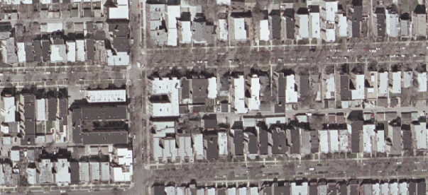
Chicago: two-flats, three-flats, and courtyard buildings.
Apartment buildings in Aurora…
…and how they look in Bing Bird’s Eye (rotated).
Q&A:
- Q: Many two-flats have two doors at the front, meaning they technically have separate entrances. Doesn’t this mean they should be coded Single-Family Attached?
- A: Technically, this may be correct, but from a practical standpoint we can’t make this distinction because we’re not going to look at the front of every single building. Another way of looking at this is “vertical space”–are the units side-by-side (duplexes & townhomes: SF-Attached)? Or are they stacked (apartment & condo buildings: MF)? So with a two-flat building there may be two separate front entrances but the flats are one on top of the other so this will qualify it to be coded as 1130 Multi-Family.
-
Q: The photo below shows a 2-story California-style apartment building in which each apartment has a separate front entrance. How should this be coded?
- A: Even though each apartment has a separate entrance, it is also a two-story building so units are on top of one another. This meets the criteria to code it 1130 Multi-Family.
- Q: How do I code a separate parcel that’s owned by a college, but is clearly apartments for students? Is it multifamily residential or is it higher education institutional?
- A: Code this as higher education institutional and make sure there is a “0” in the residential units field.
-
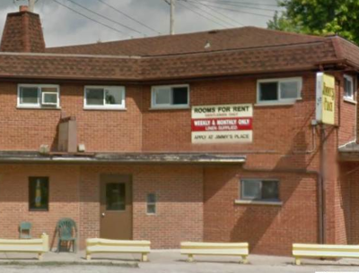
Q: How do I decide if a parcel should be coded 1250 Hotel/Motel or 1130 Multi-Family Residential? The photo below shows this building to have rooms for rent, weekly or monthly only.
- A: The main reference layer to use will be the Census data. Look at how many housing units are in that census block in the HU_TOT field. If the only way to account for that number would mean counting each unit in this building as one residential housing unit, then that would most likely mean it would be coded 1130 Multi-Family Residential. On the other hand, keep in mind that at least one manager’s apartment would occupy this building, whether hotel or apartments. Also, look at all the other residential buildings in this census block. If the number of housing units for this census block is not large enough to be able to count each unit that you estimate to be in this building as a housing unit, then you probably have reason to code it 1250 Hotel/Motel. Also, see if there’s a DnB (Dun & Bradstreet) point for this building saying it is a hotel or use other reference layers which may code it as a hotel such as the Hotels/Motels reference layer and/or the 2005 Landuse to further substantiate your 1250 Hotel/Motel code.
Mobile Home Parks and Trailer Courts (1140)
Definition: Collections of small, manufactured, uniform housing; includes common areas, office, and associated open space.
Primary Reference Layers:
- 2005 Land Use Inventory, polygons coded 1140
- MobileHomeDotNet_Geocode.shp in Reference Data folder
Discussion: Generally, these sites are on commercial parcels. The two reference layers cited above should identify most of them, so the recommended approach is to turn on both of these layers and do your entire county in one go. The MobileHome.net reference layer has not been thoroughly checked out, and may include some addresses of locations that are not mobile home communities. Additionally, it may include some communities that, while filled with manufactured housing, actually belong in the 1111 (single-family, detached) group. See the second example below.
Also, make sure the site isn’t actually a campground, which would code to 3400, Non-Public Open Space.
Examples:
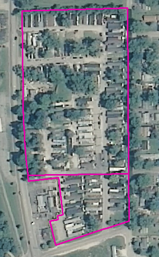
Mobile home court in Aurora.
Manufactured home community: Willow Lake Estates in Elgin. Resembles a trailer park, but functionally more like single-family. Code 1111.
Q&A:
- Q: Three parcels coded as residential by the county all have the same owner. The largest parcel has 1 house and 4 mobile homes on it; the other 2 parcels are driveway for the mobile homes. Google StreetView shows 5 mailboxes near the house and driveway to the mobile homes. I can see no signage saying this is a mobile home park. How do I code this?
- A: Even though there is no sign, all the mailboxes near the entrance indicate this is a very small mobile home park most likely with a caretaker living in the house. You can code this as 1140 Mobile Home Park.
Residential Common Open Space (1151)
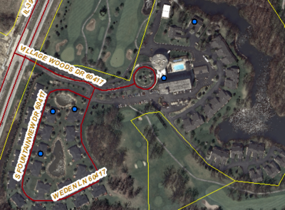
Definition: Common open space in a residential development; may be managed by homeowners’ association (HOA) or owned by the local municipality.
Discussion: These parcels are fairly common in newer developments, and basically represent the portions of a residential development that are not given over to private ownership. This may include park-like green space, detention basins, parking, or buffer strips along major roadways. In most cases they are easily identified in the parcel data because the owner is listed as such-and-such Homeowners Association, or HOA. In some instances, land serving that function is owned by the local municipality. Provided such land is not an actual park or preserve (3100 or 3300, using that muncipality’s park district website as a resource if available) and doesn’t appear to simply be “on hold” (waiting for another development to go up there), then this code can be used. This does NOT include land held by a developer for future phases of a development. In these cases the property should be coded 4100, platted Residential. Also, if a parcel consists entirely of roadway within a subdivision, it should be coded 1512: Roadway. In some lake side areas, you will find HOAs that also join together to form “water associations” or “waterway associations” for neighborhoods to support the lake ecosystem. “Water association” land will be treated similar to HOA land; any parcels totally water would be coded as Water.
A Query to Identify the Majority of these Properties: This set of queries can be used to select the majority of these properties:
- Select by Attributes in the landuse layer where
TAXNAME LIKE '%HOME%ASSOC%' - Then select from that set only those records that are uncoded
- And select from that group only the residential parcels
- And select from that group those with an improvement value of 0
These can be strung together as a single query with a series of AND statements.
Then, do a Select by Location on that set to remove those that might actually be “roadway” parcels:
- “Remove from the currently selected features in”
- Target Layer: Landuse
- Source Layer: Navteq Streets
- Selection Method: Target features intersect the Source layer feature
Finally, open the attribute table, sort on TAXNAME, and scan the list to make sure that they are all legitimate HOA entities. Non-HOA names can be picked up in the query, such as “FEDERAL HOME MORTGAGE ASSOC” Verify that there are no parcels with a value in the RES_UNITS field. In either case, you can right-click on the record to remove from the selection set.
Examples:
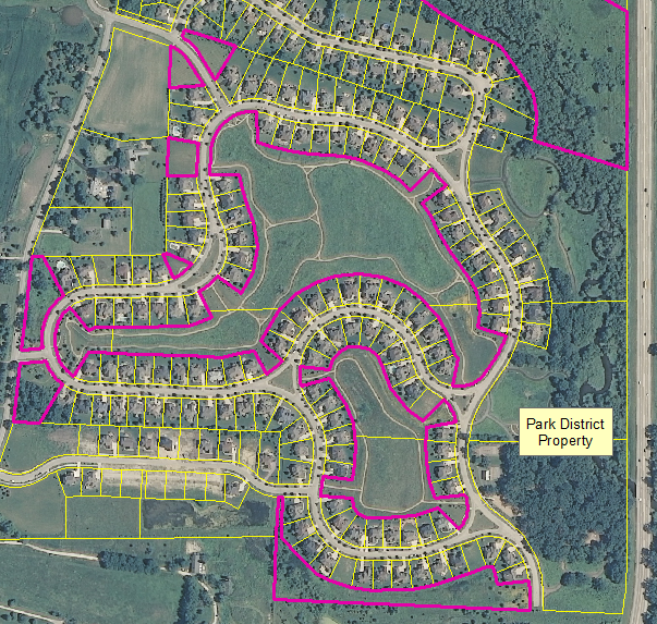
Homeowner association land in a subdivision near Batavia.
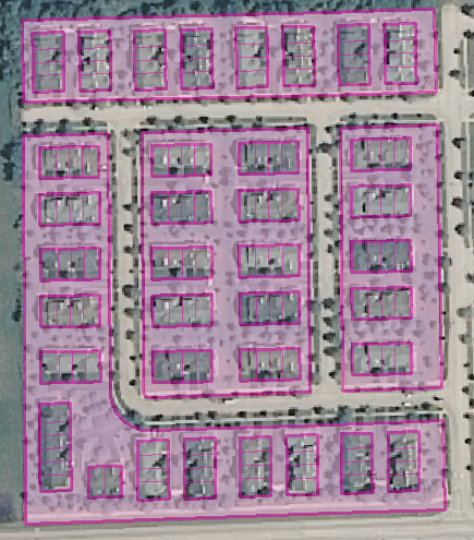
Common area surrounding a townhome development (shaded parcels).
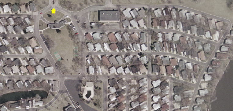
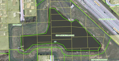
Deciding between 1151 Residential Common or 1565 Stormwater Management. The retention pond and surrounding land in the photo below is Exempt by the county and owned by the City of Hickory Hills which are two criteria that could fit for a 1151 code. However, since it only has residential bordering on about 50% of the the property, we will rule out a Residential Common code. If it was all or MOSTLY surrounded by residential, then it could be coded 1151 Residential Common. There is a Hickory Hills Park District which identified only a 4 acre Prairie View Park on the north side of this retention pond and does own one parcel on the north side of this pond so Open Space will only be a good code for that one very small parcel barely visible in this photo on the north side. All the other city-owned parcels should be coded 1565 Stormwater.
Q&A:
- Q: How do I code parcels in a residential development that are owned by a HOA and that are much more concrete than green, although they could have some green areas? The parcels are not solely a road through the development which I know would be coded Roadway. It could be mostly parking for an apartment complex. It could be a small area for the mailboxes in a neighborhood. It could be a small parcel for visitor parking in a townhome development.
- A: Go ahead and also code these areas 1151 Common Open Space. Make sure there is a “0” in the residential units field.
- Q: How do I code a recreation building with tennis courts and/or outdoor pool that is in a separate parcel and owned by a homeowners association?
- A: Since it is owned by a HOA, also code it 1151 Common Open Space. If it were owned by a municipality, then check on the internet to see if it is a designated park or recreaton center in that town. If so, it would be coded 3100 Open Space, Recreation.
- Q: How do I code a 9-hole putting green owned by a homeowners association and in a separate parcel?
- A: Code this as 1151 Common Open Space. This is because it is owned by an HOA. In order to better automate parcel-based landuse in the future, we are putting more emphasis than before on owner.
- Q: Where do we draw the line between Common Open Space in a Residential Development (1151) and Open Space, Primarily Recreation (3100)? Grande Park is a massive residential development surrounding a very large park and school in Plainfield. I’ve coded the school as K-12 Educational Facilities, but am wondering what to do about the park land. It’s all owned by the local park district; should the park be regular recreational open space, or should it be common open space since it’s technically within a residential development? What about the trail system (also in parcels owned by the park district)?
- A: The rule of thumb is to follow the parcel owner. Even though land is by a housing development, if it’s owned by a park district and looks like it could be used for recreation as open space then code it 3100 open space recreation. This applies to the trail system parcels owned by the park district as well.
- Q: What about the common areas of a new development that appear to be finished such as retention ponds in place, bushes planted, etc. but most of the residential lots do not have houses on them yet?
- A: It’s ok to code these common areas in a new development that are basically finished as 1151 Residential Common.
